Home Multi-Country Search About Admin Login
Neogene
Paleogene
Cretaceous


Compiled by: Jacques LeBlanc (2021), Stratigraphic Lexicon: The Onshore Cenozoic Sedimentary Formations of The Republic of Panama. Biosis: Biological Systems, vol. 2/1, 1-173. https://doi.org/10.37819/biosis.002.01.0095(or via https://sites.google.com/site/leblancjacques).

Search by
Select Region(s) to search
Hold Ctrl (Windows/Linux) or Command (Mac) to select multiple
Caraba Formation
Click to display on map of the Ancient World at:
Caraba Fm base reconstruction

Caraba Fm


Period: 
Paleogene, Neogene

Age Interval: 
Late Oligocene or early Miocene - Woodring, W. P. (1970)


Province: 
Panama Canal basin

Type Locality and Naming

The formation was first defined by Jones (1950, p. 901) as a facies member of the Caimito Fm. “Caraba Fm” is adopted by Woodring, W. P. (1970) for strata formerly assigned to the Caimito Fm.

The thickest well exposed section so far found is in the type region. It is located south of the Gamboa Reach of the Panama Canal, along a tributary of Río Mandinga, about 4 kilometers southwest of Gamboa and about 750 meters east of Río Caraba.

Synonym: Caraba Facies of the Caimito Fm


Lithology and Thickness

These strata, characterized by the exceptional thickness of conglomerate and conglomeratic sandstone, presumably interfinger with the Caimito Fm. The total thickness of the Caraba is unknown, even in the type region, as the base and top have not been recognized.

Where the Caraba Fm reappears northeast of the Canal (Table 1), it consists almost wholly of agglomerate, in which blocks and slabs of decite porphyry generally predominate, and agglomeratic tuff. North of Pedro Miguel the agglomerate is shown on some geologic map as part of the Pedro Miguel agglomerate, and in the area straddling the part of Madden Highway south of the Transisthmian (or Boyd-Roosevelt) Highway overpass as part of the Caimito Fm. Exposures may be seen at the falls on the east side of Madden Highway at the monument site four kilometers south of the overpass and on abandoned Army roads east of the highway.
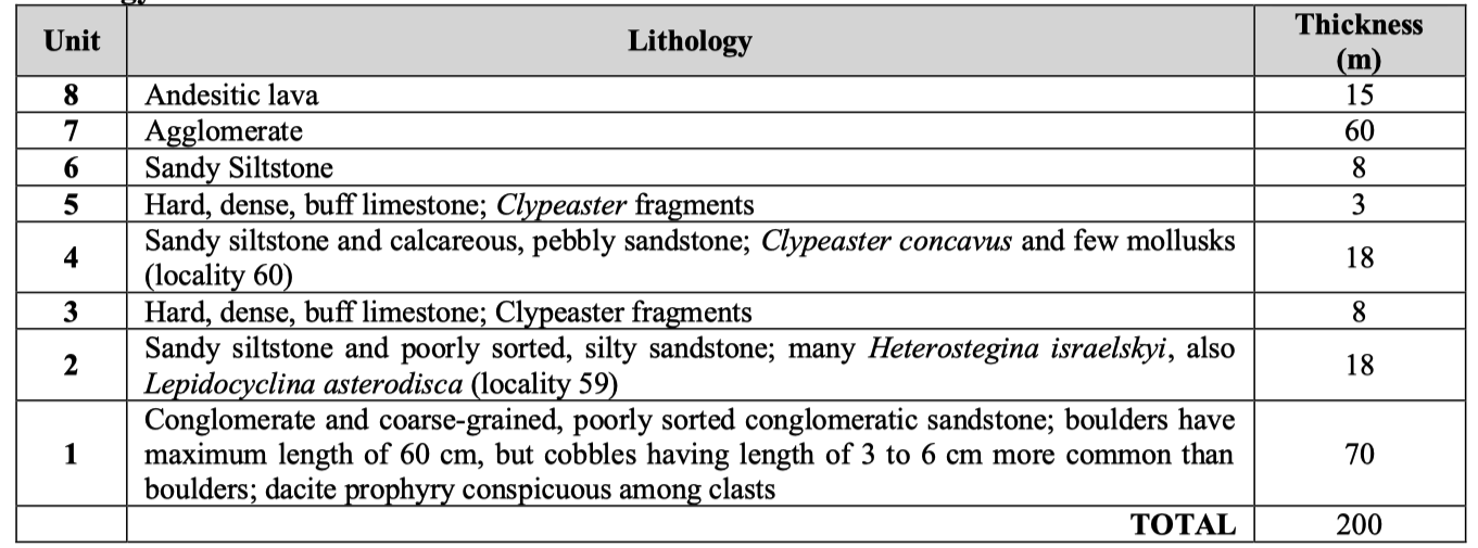
Thickness: >200 m

[Table 1. The section exposed along a tributary of Río Mandinga, as recorded by Stewart et al. (1980) and Woodring (1982).]


Lithology Pattern: 
Aus Conglomerate


Relationships and Distribution

Lower contact

Upper contact

Regional extent


GeoJSON

{"type":"Feature","geometry":{"type":"MultiPolygon","coordinates":[[[[-79.87,9.42],[-79.84,9.42],[-79.81,9.4],[-79.78,9.35],[-79.68,9.31],[-79.55,9.35],[-79.57,9.27],[-79.56,9.2],[-79.54,9.16],[-79.57,9.14],[-79.53,9.11],[-79.47,9.1],[-79.4,9.08],[-79.37,9.05],[-79.46,8.99],[-79.52,8.93],[-79.57,8.88],[-79.61,8.89],[-79.64,8.93],[-79.69,8.98],[-79.73,9.02],[-79.79,9.06],[-80.33,8.92],[-80.43,8.92],[-80.36,9.04],[-80.36,9.06],[-80.49,9.03],[-80.51,9.12],[-80.01,9.35],[-79.87,9.42]]]]}}

Fossils

  • Larger foraminifera: Nummulites panamensis Cushman, Heterostegina israelskyi Gravell and Hanna, Lepidocyclina asterodisca Nuttall,
  • Coral: Goniopora cf. G. cascadensis Vaughan
  • Gastropods: Pachycrommium? aff., P.? trinitatensis (Mansfield), Ficus sp., group of F. ventricosa (Sowerby)
  • Echinoid: Clypeaster concavus Cotteau


Age 


Age Span: 

    Beginning stage: 
Chattian

    Fraction up in beginning stage: 
0

    Beginning date (Ma): 
27.29

    Ending stage: 
Chattian

    Fraction up in the ending stage: 
0.5

    Ending date (Ma):  
25.16

Depositional setting


Depositional pattern:  


Additional Information

References:

  • Jones (1950)
  • Woodring, W. P. (1957, 1970, 1982);
  • Stewart et al. (1980)


Compiler:  

Jacques LeBlanc (2021), Stratigraphic Lexicon: The Onshore Cenozoic Sedimentary Formations of The Republic of Panama. Biosis: Biological Systems, 2(1), 173 pp. https://doi.org/10.37819/biosis.002.01.0095 (or via https://sites.google.com/site/leblancjacques)